How to use GIS for Construction?
How to use GIS for Construction
Geographic Information Systems has transformed the construction sector through enhanced planning, execution, and management. With the integration of spatial data, construction firms are able to improve decision-making processes, lower expenses, and improve workflows. In a rapid construction setting, accurate and real time data is essential for successful project completion. GIS assists construction professionals to see and analyze spatial information throughout the entire project lifecycle. Efficient use of GIS in construction ensures project efficiency and sustainability from site selection, through execution, and up to project maintenance.
Using GIS Technology for Construction Purposes
The geographic information system provides helpful geographic information which enables construction specialists to make precise decisions. Companies can better manage a project’s success by mapping the design of the land, considering environmental aspects, and spatially representing the already existing infrastructures. Furthermore, GIS’s ability to examine zoning regulations, topography, and utility servicing makes it a critical component of contemporary construction work.
Advantages of GIS Technology in Construction Activities
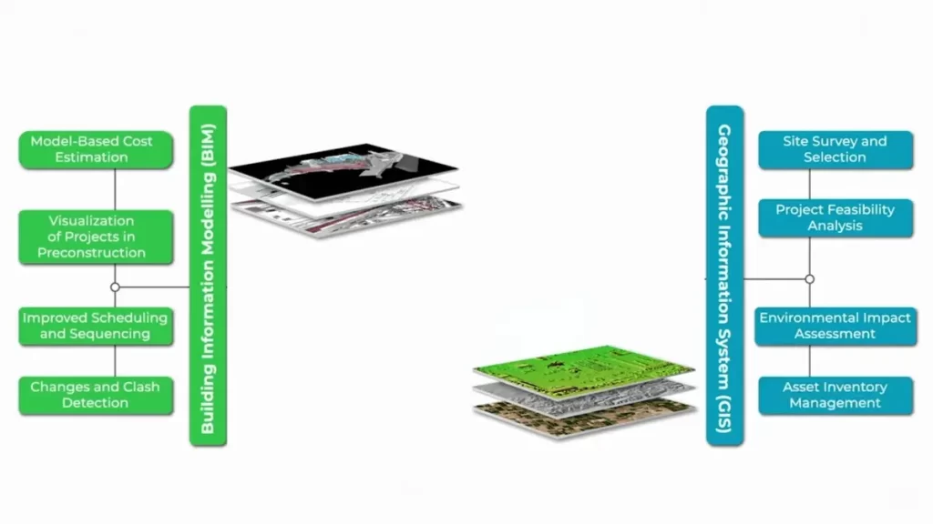
Various construction activities benefit from different advantages offered by GIS Technology. Site selection is one of the most crucial benefits. Construction firms are able to study ecological, accessibility, and even land use impacts before the project site is determined which makes the site meet all conditions while diminish chances of complications. Furthermore, there is improved project planning as another advantage. The integration of Geographic data in real-time increases terrain and weather associated risks’ planning which is hugely beneficial. These risks can therefore be addressed proactively before they alter the construction process.
Another benefit of GIS systems is their contribution to resource management. Construction companies can monitor the position of materials, labor, and machinery, which ensures that every work unit is functioning efficiently and effectively. This saves resources and also prevents resource shortfalls from causing project delays. Moreover, GIS contributes to risk assessment. Construction companies can analyze flood zones, earthquake-sensitive regions, and other dangers to devise methods to shield a project from associated risks. GIS has the added advantage of accurately mapping infrastructure and utility components such as transportation networks and drainage systems. This minimizes mistakes that may be expensive to rectify and maximizes the integration of existing infrastructure.
Using GIS for Construction Planning
The application of GIS technology for construction planning is best illustrated with a step by step approach. Step one is data collection, which refers to the process of obtaining spatial information for mapping purposes through satellite images, surveys, and drone flights to build a project database. This data is used to establish the basis for all future plans and decisions. After gathering data, a site analysis is done. The GIS program assists in evaluating soil type, topography, and zoning regulations to decide if construction is possible. This analysis guarantees that the site selected is not only available for the proposed development, but also meets legally defined requirements.
Planning for construction entails the elements of design and modeling, which are fundamental parts of GIS. The integration of GIS into CAD and BIM software allows construction experts to build realistic 3D models of the project. These models serve as replicas of the construction site enabling informed decisions to be made for the design, structure, and arrangement of the site. Another notable area where GIS comes in handy is logistics and resource allocation. Construction companies can improve workflow and effectiveness by planning transportation routes, coordinating material deliveries, and managing workforce distribution. Finally, GIS is essential in monitoring and maintenance. After the construction projects are done, maintenance, infrastructure updates, and asset management can be tracked with ease using GIS. This helps ensure that the built facilities remain in good condition over time.
Negative Effects of GIS Fraud on Construction Firms
Most construction companies fail terribly to incorporate GIS software within their operations due to lack of information, would be willing to resort to illegal means as oppose to acquiring an acceptable solution to the problem. To cover their GIS fraud, they might “create” fake boundaries to alter property records, terming them as mapped, implemented a boundary verification so they appear to have implemented boundary marking or erected fence boundaries.
They might even go to the extent of creating fake attributes and updating property records where a record could associate a map, and mark an attribute as a property owner’s name. These illegal practices can only be curbed by GIS vendors producing software that is equipped with “security features” which require a unique identifier that will restrict some actions such as casting blobs or dummy marks on entries. Constructing a mapping system is one simple and effective way to eliminate or minimize fraud. The construction system GIS fraud and abuse by integrating datasets on ownership of building, property, mapping, attributes, and civil society.
You will Love to Read: What Is a Revision in Construction Submittals?
GIS technology is essential in making construction sites safer. By identifying risk factors and safety threats, organizations are able to take precautionary actions that protect people and machinery. As a result, accidents as well as injuries are less likely to happen. Furthermore, GIS offers assistance in the area of disaster management by monitoring real-time weather, natural catastrophes, and even emergency response methods. This data helps construction companies plan for unforeseen situations and minimize damages.
Conclusion
Knowing how to apply GIS to the construction area can radically change the management of the project and the decisions that need to be made while performing the tasks. Throughout the planning, implementation, as well as maintenance phases of a project, companies are able to make better use of financial resources, lessen risks, and successfully complete their construction projects. It is certain that GIS will remain a leading weapon for achieving technological breakthroughs as well as for providing societal benefits in the construction sector.
With its soaring capabilities in improving the selection of sites, project planning, effective resource allocation, and construction safety, modern construction companies now find GIS to be an invaluable technology. The use of GIS is expected to contribute to improved efficiency, cost-savings, and enhanced project delivery in the construction business. The future of construction will depend on data-based decision support tools, and that shift is led by GIS.
